캐나다와 미국 사이에는 국경이 있지만 자연에는 없다
캐나다와 미국 사이에는 국경이 있지만 자연에는 없다
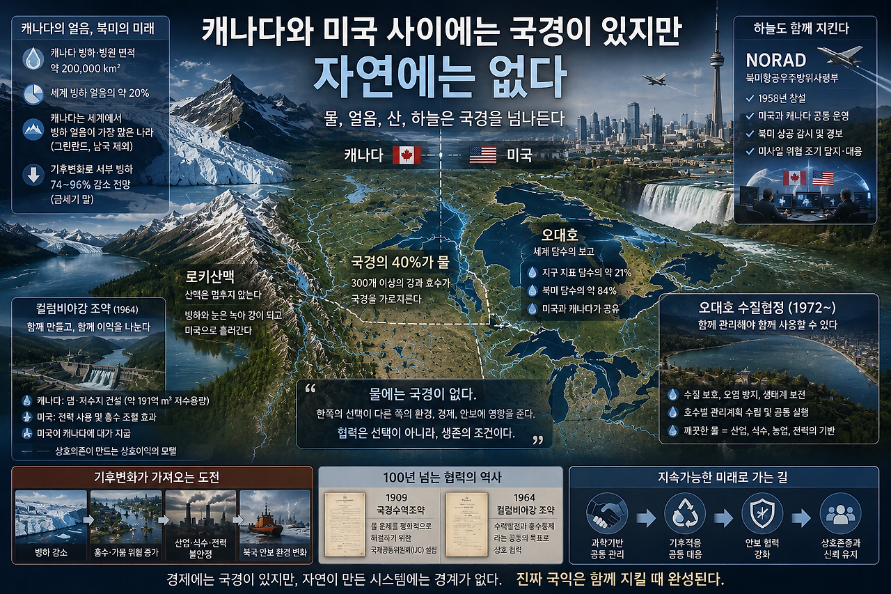
미국과 캐나다의 국경은 길다.
지도에서 보면 거의 완벽한 직선으로 보이는 구간도 있다.
특히 북위 49도선을 따라 이어지는 서부의 국경을 보면 인간이 얼마나 자신 있게 자연 위에 선을 그을 수 있는지 보여주는 것 같다.
이 선의 아래는 미국이고, 위는 캐나다다.
법이 달라지고, 통화가 달라지고, 정부가 달라진다.
상품이 이 선을 넘으면 관세를 매길 수도 있다.
사람이 넘으면 여권을 확인한다.
트럼프는 바로 이런 선을 중요하게 생각하는 정치인이다.
미국에서 생산했는가?
캐나다에서 생산했는가?
누가 누구에게 더 많이 팔고 있는가?
어느 나라가 미국의 시장을 이용해 더 많은 이익을 얻고 있는가?
2026년 여름에도 미국과 캐나다의 무역갈등은 계속됐다. 트럼프 행정부는 캐나다산 자동차·유제품 등에 추가 관세를 발표했고, 협상 과정에서 일부 조치의 시행을 조정하면서도 캐나다가 미국과의 교역에서 부당한 이익을 얻고 있다는 주장을 이어갔다. 백악관은 급기야 캐나다가 미국에 ‘무임승차’를 해왔다고 표현했다. (The White House)
경제의 관점에서 보면 가능한 논쟁이다.
그런데 지도를 조금 다르게 펼쳐보면 이상한 것이 보인다.
국경선을 지우고, 산맥과 강과 호수만 남겨보는 것이다.
그러면 미국과 캐나다를 나누던 선이 갑자기 별 의미가 없어져 버린다.
로키산맥은 캐나다에서 미국으로 이어지고, 강은 국경을 가로지르며, 오대호의 한가운데에는 국제국경이 지나간다.
심지어 두 나라는 하늘까지 함께 지키고 있다.
1958년 만들어진 NORAD, 북미항공우주방위사령부는 미국군도 아니고 캐나다군도 아닌 미국과 캐나다가 공동으로 운영하는 세계적으로도 독특한 양국 통합 군사체계다. 지금도 북미의 항공우주 경보와 방어를 두 나라가 함께 수행하고 있다. (노라드)
미국과 캐나다는 분명 다른 나라다.
그런데 자연과 안보의 관점에서 보면 때때로 하나의 대륙 시스템처럼 움직인다.
바로 이 지점에서 나는 트럼프식 경제 내셔널리즘이 가진 가장 어려운 문제를 발견한다.
경제에는 국경을 세울 수 있다.
하지만 자연에는 어디까지 국경을 세울 수 있을까?
캐나다에는 정말 많은 얼음이 있다
네팔의 빙하 붕괴를 보면서 처음에는 미국 로키산맥을 생각했다.
미국에도 빙하가 있기 때문이다.
그런데 지도를 조금 위로 올리면 문제의 규모가 달라진다.
캐나다다.
캐나다 천연자원부에 따르면 캐나다에는 약 20만㎢의 빙하와 빙원이 존재한다.
그린란드와 남극의 거대한 빙상을 제외하면 캐나다는 지구상에서 가장 많은 빙하 얼음을 가진 국가다. 세계 빙하 얼음 부피의 약 20%가 캐나다에 있는 것으로 평가된다.
그 가운데 약 15만㎢는 캐나다 북극제도에 있고, 약 5만㎢는 서부와 북부 산악지역에 분포한다. (Natural Resources Canada)
이 정도면 캐나다의 빙하는 단순한 관광자원이 아니다.
거대한 물 저장고이고, 기후를 기록하는 장치이며, 강과 생태계를 지탱하는 자연 인프라다.
문제는 이 얼음도 줄어들고 있다는 것이다.
캐나다 정부의 기후평가에서는 지난 수십 년 동안 북극과 산악빙하가 지속적으로 얇아졌고, 캐나다 서부 산악지역에서는 중간 수준의 온실가스 배출 시나리오에서도 금세기 말까지 빙하 부피의 74~96%가 사라질 수 있다고 전망한다. 캐나다 북극의 빙하와 빙원 손실 역시 세계 해수면 상승에 상당한 영향을 미친다. (Natural Resources Canada)
최근 캐나다 정부는 캐나다 전체가 세계 평균의 약 두 배 속도로 온난화되고 있고, 북극지역은 약 세 배 빠르다고 설명하고 있다. (Natural Resources Canada)
그러면 자연스럽게 이런 생각이 든다.
캐나다의 얼음이 녹는 것은 캐나다만의 문제일까?
그렇지 않다.
다만 한 가지는 구분해야 한다
여기에서 흔히 나오는 말이 있다.
캐나다는 세계에서 담수가 가장 풍부한 나라 가운데 하나이고, 그것은 빙하가 많기 때문이다.
절반은 맞고 절반은 수정할 필요가 있다.
캐나다 정부에 따르면 캐나다는 세계 담수의 약 20%를 가지고 있으며, 매년 순환하며 다시 공급되는 세계 재생가능 담수의 약 7%를 보유한다. (Canada)
엄청난 양이다.
하지만 현재 캐나다에 존재하는 막대한 담수가 전부 산악빙하에서 공급되는 것은 아니다.
캐나다에는 수많은 호수와 강, 습지와 지하수가 있다.
그리고 오대호를 비롯한 거대한 호수체계 가운데 상당수는 과거 빙하기의 거대한 빙상이 남긴 지형적 유산이다.
즉 오늘날의 빙하가 캐나다 담수 전체를 계속 채워주고 있기 때문이라기보다, 빙하가 오랜 시간 동안 캐나다의 지형 자체를 만들어놓았다고 보는 편이 정확하다.
이 구분은 중요하다.
왜냐하면 현재 빙하가 녹는 문제는 단순히 ‘물이 많아진다’로 끝나지 않기 때문이다.
처음에는 융빙수가 증가할 수 있다.
하지만 빙하가 계속 작아지면 언젠가는 여름철에 강으로 공급할 얼음 자체가 줄어든다.
쉽게 말하면 거대한 얼음 저수지에서 당겨 쓰고 있는 셈이다.
처음에는 물이 많이 나온다.
그러나 저수지가 작아지면 이야기가 달라진다.
캐나다 정부 역시 서부 빙하 감소가 앞으로 강과 하천으로 공급되는 빙하 융빙수 감소로 이어져 담수 이용에 영향을 미칠 수 있다고 전망한다. (Natural Resources Canada)
이제 이것은 관광지의 빙하가 사라지는 문제가 아니다.
물의 시간표가 바뀌는 문제다.
물은 여권이 없다
미국과 캐나다의 국경에는 300개가 넘는 강과 호수가 걸쳐 있거나 국경을 가로지른다.
놀랍게도 물이 차지하는 구간만 미국·캐나다 국경 전체의 약 40%에 이른다. (Global Affairs Canada)
그래서 두 나라는 이미 100년도 전에 이 문제를 알아차렸다.
1909년 미국과 캐나다는 국경수역조약(Boundary Waters Treaty)을 체결했다.
한쪽 국가가 물의 흐름이나 수위를 바꿔 다른 나라에 영향을 미칠 수 있는 경우 마음대로 결정하지 않도록 하고, 이를 관리하기 위해 국제공동위원회(IJC)를 만들었다. (Canada)
왜 1909년에 이런 조약이 필요했을까?
답은 단순하다.
강물은 국경초소에서 멈추지 않기 때문이다.
캐나다에서 댐을 만들면 미국의 수위가 달라질 수 있다.
미국에서 오염물질을 흘려보내면 캐나다로 갈 수 있다.
한 나라가 물을 지나치게 끌어다 쓰면 다른 나라의 농업과 발전에 영향을 줄 수 있다.
자연스럽게 두 나라는 협력할 수밖에 없었다.
경제 내셔널리즘이 등장하기 훨씬 전부터 지리가 두 나라에 협력을 강요한 셈이다.
컬럼비아강이라는 거대한 공동사업
그 관계를 가장 잘 보여주는 강 가운데 하나가 컬럼비아강이다.
컬럼비아강은 캐나다 브리티시컬럼비아에서 시작해 미국 워싱턴주를 지나 태평양으로 흘러간다.
미국과 캐나다는 1964년부터 컬럼비아강 조약을 운영해왔다.
캐나다 쪽에 거대한 댐과 저수지를 건설하고 두 나라가 이를 연계해 운영하면서 수력발전을 늘리고 미국 하류지역의 홍수 위험을 낮추는 구조다.
캐나다 정부 설명에 따르면 캐나다는 약 191억㎥에 해당하는 저수용량을 전력생산과 양국의 홍수통제를 위해 운용해왔다. 미국은 그 덕분에 추가로 얻는 전력과 홍수조절 효과에 대해 캐나다에 대가를 지급해왔다. (Canada)
여기서 아주 재미있는 일이 벌어진다.
캐나다의 댐이 미국을 보호한다.
미국은 그 가치에 돈을 지불한다.
이것이야말로 가격표가 붙은 상호의존이다.
그런데 누구도 이것을 '왜 미국이 캐나다에 돈을 주느냐.' 만으로 설명하지 않는다.
미국은 돈을 지불하지만, 대신 홍수 위험을 줄이고, 더 안정적으로 수력발전을 한다.
캐나다 역시 돈과 전력의 혜택을 얻는다.
즉 돈이 오가는 것만 보면 비용이지만, 전체 시스템을 보면 보험과 인프라에 대한 투자다.
지난 편에서 동맹 이야기를 하며 했던 질문과 놀랍도록 비슷하다.
그리고 오대호가 있다
이제 조금 더 동쪽으로 가보자.
여기에는 미국과 캐나다가 도저히 분리할 수 없는 것이 하나 있다.
오대호다.
미시간호를 제외한 네 호수(슈피리어호, 미시간호, 휴런호, 이리호, 온타리오호)에는 미국과 캐나다의 국경이 지나간다.
미국 EPA에 따르면 오대호는 북미 지표 담수의 약 84%, 세계 지표 담수의 약 21%를 담고 있다. (US EPA)
숫자가 너무 커서 오히려 감각이 없어진다.
하지만 오대호 주변의 도시를 생각하면 의미가 보인다.
시카고가 있고, 디트로이트가 있고, 클리블랜드와 버펄로가 있다.
캐나다 쪽에는 토론토와 해밀턴이 있다.
자동차산업과 철강, 화학과 제조업, 농업과 항만, 수력발전, 그리고 수천만 명의 식수가 이 거대한 물 시스템에 연결돼 있다.
캐나다 정부도 오대호가 양국의 산업·상업·농업·도시발전에 핵심적인 역할을 해왔다고 설명한다. (Canada)
여기에서는 물 한 방울의 국적을 구분하는 일이 거의 우스워진다.
오대호 한가운데 국경선은 그어져 있지만, 물은 계속 움직인다.
한쪽 호수의 수위가 변하면 다른 호수와 연결하천에도 영향을 준다.
오염도 이동한다.
생물도 이동한다.
대기도 연결되어 있다.
그래서 미국과 캐나다는 1972년부터 오대호 수질협정을 운영하면서 물을 공동 관리해왔다. 지금도 양국 정부가 각 호수별 관리계획을 함께 만들고 있다. (US EPA)
미국 EPA는 미국과 캐나다 사이에 환경과 생태계 관리를 위한 연방 수준 국제협정만 40개가 넘고, 미국 주정부와 캐나다 주정부 사이의 추가 협정도 100개 이상이라고 설명한다. (US EPA)
이것을 보면 한 가지 사실이 분명해진다.
미국과 캐나다는 자유무역협정 때문에 연결된 나라가 아니다.
무역협정이 만들어지기 훨씬 전부터 자연 때문에 연결되어 있던 나라다.
그렇다면 오대호는 범람할까
기후변화를 생각하면 자연스럽게 이런 질문이 생긴다.
빙하가 녹고 강수량이 변한다면 오대호에도 문제가 생기지 않을까?
가능하다.
다만 여기서는 정확하게 구분할 필요가 있다.
캐나다 로키산맥의 빙하가 녹아 그 물이 그대로 오대호로 쏟아져 들어가 수위를 높이는 구조는 아니다.
수계가 다르기 때문이다.
오대호 수위에 직접적인 영향을 미치는 것은 주로 오대호 유역에 내리는 비와 눈, 강을 통해 들어오는 유입량,
그리고 호수 표면에서 증발하는 물의 양이다.
그러니까 '캐나다 빙하 융해 → 오대호 범람'이라고 곧바로 연결하면 과학적으로 정확하지 않다.
하지만 기후변화와 오대호는 분명히 연결되어 있다.
기온이 올라가면 증발량이 달라지고, 눈이 쌓이고 녹는 시기가 바뀌며, 강수의 양과 계절적 분포도 변한다.
그 결과 어떤 시기에는 기록적인 고수위가 나타날 수 있고, 다른 시기에는 반대로 저수위가 문제가 될 수 있다.
따라서 우리가 봐야 할 것은 단순한 ‘수위 상승’보다 수위의 극단적인 변동이다.
이런 변화가 반복되면 항만과 해운, 연안 부동산, 취수시설, 도로와 하수시설, 농업과 제조업까지 영향을 받는다.
그래서 물은 환경정바카라의 이야기가 아니라 경제정바카라의 이야기가 된다.
미국 자동차에는 캐나다 국적을 붙일 수 있을까
이 이야기를 산업으로 가져오면 훨씬 더 재미있어진다.
미국과 캐나다의 자동차산업은 수십 년 동안 하나의 공급망처럼 발전했다.
자동차 한 대가 완성될 때까지 부품이 미국과 캐나다 국경을 여러 번 오가는 경우도 있다.
철강과 알루미늄, 원유와 전력, 목재와 농산물도 마찬가지다.
그런데 경제 내셔널리즘은 이 상품들에 다시 국적을 붙이기 시작한다.
미국산인가?
캐나다산인가?
필요한 질문일 수 있다.
그러나 공급망이 이미 수십 년 동안 하나로 얽혀 있다면 그 국적을 완벽하게 나누는 순간 새로운 비용이 생긴다.
자연에서도 같다.
미국의 물, 캐나다의 물이라고 구분할 수는 있다.
하지만 물이 이동하기 시작하면 이야기가 달라진다.
그래서 북미라는 공간을 보면 경제학에서 사용하는 국가 단위와 실제 지리적 시스템 사이에 미묘한 충돌이 생긴다.
심지어 미국의 하늘도 캐나다와 함께 지킨다
이것이 가장 극적으로 드러나는 것이 NORAD다.
미국과 캐나다는 무역에서는 서로 관세를 매길 수 있다.
그런데 북미 상공으로 미사일이나 적대적인 항공기가 접근하면 이야기가 완전히 달라진다.
미국과 캐나다는 하나의 경보체계로 본다.
NORAD는 탄도미사일 공격을 탐지하고 경고하며, 북미의 항공우주 영역을 감시한다. 2006년부터는 해양경보 임무까지 포함됐다. (노라드)
왜 그렇게 되었을까?
러시아에서 북미로 접근하는 미사일에게 미국과 캐나다의 국경은 의미가 없기 때문이다.
북극을 통과해 들어오는 위협을 미국이 미국 영토에 도착한 뒤에야 발견한다면 너무 늦다.
캐나다의 북쪽 역시 미국 방위의 앞선 공간이다.
그래서 두 나라는 “네 하늘은 네가 지키고 내 하늘은 내가 지키자.” 고 하지 않았다.
“북미의 하늘을 같이 지키자.” 고 했다.
이것은 패권을 이해하는 데 꽤 중요한 사례라고 생각한다.
안보는 지리를 따라간다.
물도 지리를 따라간다.
기후 역시 지리를 따라간다.
정치가 아무리 국경을 강조해도 지리는 사라지지 않는다.
그런데 기후변화는 관계를 더 복잡하게 만든다
캐나다의 북극은 빠르게 변하고 있다.
빙하가 줄어들고, 영구동토층이 녹으며, 북극해의 해빙도 감소한다.
이는 단순한 환경변화가 아니다.
북극항로가 열리는 기간이 길어질 수 있고, 러시아와 중국의 북극 활동이 늘어나며, 광물과 에너지 개발 가능성도 달라진다.
즉 기후변화가 안보지도를 바꾼다.
미국 입장에서 캐나다 북부의 전략적 중요성이 오히려 더 커질 수도 있다는 뜻이다.
트럼프가 캐나다를 무역 상대국으로만 본다면 놓칠 수 있는 부분이다.
캐나다는 미국 북쪽에 있는 외국이기도 하지만, 동시에 미국 본토방위의 북쪽 공간을 함께 관리하는 국가다.
그리고 그 공간에는 세계적으로도 엄청난 양의 얼음과 담수가 존재한다.
‘America First’는 어디까지 가능한가
여기에서 나는 다시 트럼프의 논리로 돌아온다.
"America First"
나는 이 말을 무조건 틀린 주장이라고 생각하지 않는다.
미국 대통령이라면 미국인의 이익을 먼저 생각하는 것이 이상하지 않다.
한국 대통령이 한국인의 이익을 우선하는 것과 다르지 않다.
문제는 미국의 이익이 어디에서 끝나는가다.
캐나다의 경제가 어려워지는 것이 미국에 언제나 이익일까?
캐나다의 전력망이 불안해지는 것은 미국과 무관할까?
캐나다의 산불 연기가 미국으로 내려오면 그것은 캐나다 문제일까?
캐나다에서 시작한 강의 수량이 바뀌면 미국 농업과 수력발전에는 영향이 없을까?
오대호의 수질이 나빠졌는데 미국 쪽 물만 깨끗하게 만들 수 있을까?
캐나다 북극의 안보가 불안해져도 미국은 안전할까?
이 질문들을 하나씩 따라가다 보면 ‘국익’의 경계가 생각보다 모호해진다.
이웃의 이익 가운데 일부가 결국 나의 이익이기 때문이다.
이것이 상호의존이다.
패권의 가격표에서 빠뜨리기 쉬운 것
우리는 비용을 계산할 때 보이는 돈을 먼저 센다.
미군 주둔비, 국제기구 분담금, 기후대응 투자비, 외국에 제공하는 지원, 이것들은 숫자로 나온다.
그래서 줄이기도 쉽다.
하지만 시스템이 주는 이익은 숫자로 계산하기 어렵다.
캐나다와 100년 넘게 물 문제를 협력해왔기 때문에 일어나지 않은 분쟁의 가격은 얼마일까?
캐나다의 저수지가 미국의 홍수를 막아준 가치는 얼마일까?
NORAD를 통해 북쪽에서 위협을 더 빨리 발견할 수 있는 가치는 얼마일까?
오대호를 공동 관리하면서 확보한 산업과 식수의 안정성은 얼마일까?
이런 것들은 예산서에서 하나의 숫자로 보이지 않는다.
그래서 쉽게 공짜라고 착각한다.
하지만 공짜가 아니다.
수십 년 동안 만들어온 제도와 신뢰가 작동하고 있기 때문에 보이지 않을 뿐이다.
동맹과 똑같다.
캐나다의 물은 캐나다에만 머물지 않는다
캐나다에는 세계 담수의 상당 부분이 있다.
그리고 세계적으로도 엄청난 규모의 빙하가 있다.
하지만 이 글에서 내가 흥미롭게 보는 것은 그 양 자체가 아니다.
연결되는 방향이다.
서부에서는 컬럼비아강이 미국으로 내려간다.
중부와 동부에는 수많은 국경하천이 있다.
오대호는 두 나라가 함께 가진다.
대기는 국경을 건너고, 산불 연기도 건넌다.
북극의 군사적 위협 역시 국경을 구분하지 않는다.
그래서 미국과 캐나다는 경제적으로 싸울 수는 있어도, 물리적으로 완전히 분리될 수는 없다.
여기에 기후변화가 들어가면 관계는 더욱 복잡해진다.
빙하가 줄어든다고 해서 내일 미국 수도꼭지에서 물이 나오지 않는다는 뜻은 아니다.
캐나다의 빙하가 녹는다고 곧바로 오대호가 범람하는 것도 아니다.
그렇게 단순하게 연결하면 안 된다.
하지만 빙하와 적설, 강수와 증발, 강과 저수지, 해수면과 해류가 장기간에 걸쳐 변하면,
그 결과는 국경을 넘는다.
그리고 그 변화에 적응하려면 두 나라가 다시 함께 돈을 써야 한다.
여기에도 가격표가 붙는다.
나는 여기서 2011년의 질문을 다시 생각한다
국제통상론을 배우던 당시에는 국가 간 경제가 다시 블록으로 나뉠 수 있다는 이야기가 흥미로웠다.
지금 실제로 그런 모습이 나타나고 있다.
미국은 중국을 공급망에서 밀어내려 하고, 미국 중심의 산업을 다시 만들려고 한다.
캐나다와 같은 오랜 동맹국과도 무역조건을 다시 계산한다.
경제에는 다시 국적이 생기고 있다.
그런데 2011년의 나는 지금만큼 기후를 생각하지 않았다.
기후변화는 이 논리에 매우 이상한 변수를 집어넣는다.
경제는 블록화할 수 있다.
상품의 원산지를 따질 수 있고, 관세를 매길 수 있으며, 공급망을 우방국끼리 다시 만들 수도 있다.
그런데 지구의 시스템은 블록화할 수 없다.
미국 블록의 대기와 중국 블록의 대기를 만들 수는 없다.
북미의 물도 마찬가지다.
그래서 나는 캐나다를 보면서 이 카지노 게임에서 처음으로 조금 다른 생각을 하게 됐다.
패권국이 지불하는 비용 가운데는 다른 나라를 위해 쓰는 것처럼 보이지만, 사실 자기 자신을 위해 쓰는 돈도 많다.
동맹이 그렇고, 국경수역 관리가 그렇고, 기후협력이 그렇다.
그런데 이 비용을 하나씩 “왜 우리가 내야 하지?” 라고 묻기 시작하면 당장의 장부는 좋아질 수도 있다.
문제는 장부 밖에 존재하는 자산이다.
트럼프가 미국의 비용을 줄이는 데 성공할지는 모른다.
하지만 비용을 줄일 때마다 우리는 반드시 하나를 같이 계산해야 한다.
그 돈으로 무엇을 사고 있었는가?
캐나다와의 협력으로 미국이 사고 있던 것은 단순한 우호관계가 아니었다.
물이었다.
전력이었다.
홍수통제였다.
북쪽의 안보였다.
그리고 무엇보다 안정된 북미라는 공간이었다.
관세표에는 나오지 않는 것들이다.
그런데 이제 더 큰 물을 봐야 한다.
오대호다.
미국과 캐나다가 공유하는 이 거대한 담수체계에는 세계 지표 담수의 약 5분의 1이 들어 있다.
그리고 기후변화는 이 호수의 물을 단순히 늘리거나 줄이는 것이 아니라, 물의 변동성을 바꿀 가능성이 있다.
수위가 높아지면 문제가 생기고, 너무 낮아져도 문제가 생긴다.
항만과 제조업, 도시와 식수, 농업과 전력까지 함께 움직인다.
빙하를 보며 시작했던 이야기가 이제 미국 산업의 심장부로 들어오기 시작한다.
다음 화
오대호의 물은 누구의 것인가
오대호에는 미국과 캐나다의 국경선이 지나간다.
하지만 물에는 선이 그어져 있지 않다.
세계 최대급 담수체계의 수위가 흔들리면 환경만 흔들리는 것이 아니다.
시카고와 디트로이트, 토론토와 버펄로, 자동차와 철강, 항만과 식수가 함께 흔들린다.
7화에서는 기후변화가 어떻게 물의 문제가 되고, 물이 다시 미국 제조업과 패권의 문제가 되는지 따라가 보려고 한다.
Episode 6
There's a Border Between Canada and America — Nature Doesn't Recognize It
The US-Canada border is long. Some stretches, drawn along the 49th parallel across the West, look almost suspiciously straight on a map — a reminder of just how confidently humans can draw a line across nature. South of it is the United States. North of it is Canada. Different laws, different currency, different government. Goods that cross it can be taxed. People who cross it get their passports checked.
Trump is a politician who takes that line very seriously. Was it made in America or Canada? Who's selling more to whom? Which country is profiting unfairly from access to the other's market? The US-Canada trade dispute continued through the summer of 2026: the Trump administration announced additional tariffs on Canadian autos and dairy, adjusted the timing of some measures during negotiations, but kept pressing the claim that Canada was gaining unfairly from trade with the US. At one point, the White House went so far as to describe Canada as a "free rider."
Judged purely as economics, that's a defensible argument. But unfold the map a little differently — erase the border, and leave only the mountains, rivers, and lakes — and the line separating America and Canada suddenly loses most of its meaning. The Rockies run from Canada straight into the US. Rivers cross the border without pausing. The international boundary runs directly through the middle of the Great Lakes. The two countries even guard their skies together: NORAD, the North American Aerospace Defense Command established in 1958, is neither an American nor a Canadian military organization — it's a genuinely unique bi-national command, jointly run by both countries, still handling aerospace warning and defense across North America to this day.
America and Canada are, without question, separate nations. But viewed through the lens of nature and security, they sometimes behave as a single continental system. And that's exactly where I think Trump-style economic nationalism runs into its hardest problem: you can build borders around an economy. How far can you actually build them around nature?
Canada Has an Extraordinary Amount of Ice
Watching Nepal's glacier collapse, my first instinct was to think about America's Rockies, since the US has glaciers too. But shift the map further north, and the scale of the issue changes entirely.
Canada. According to Natural Resources Canada, the country holds roughly 200,000 square kilometers of glaciers and ice fields. Set aside Greenland and Antarctica's massive ice sheets, and Canada holds more glacial ice than any other country on Earth — an estimated 20% of the world's glacier ice volume. Of that, roughly 150,000 square kilometers sits in Canada's Arctic Archipelago, with another 50,000 spread across the western and northern mountains.
At that scale, Canada's glaciers are far more than a tourist attraction. They're a massive water reservoir, a record of the climate, and natural infrastructure holding up rivers and ecosystems.
And that ice is shrinking too. Canada's own government climate assessment finds that Arctic and mountain glaciers have thinned steadily for decades, and projects that under a moderate emissions scenario, western Canadian mountain glaciers could lose 74% to 96% of their volume by the end of the century. Loss of Arctic ice caps and glaciers is also a meaningful contributor to global sea-level rise. Canada's government now reports that the country as a whole is warming at roughly twice the global average, and the Arctic at roughly three times that rate.
Which raises an obvious question: is Canada's melting ice really just Canada's problem? It isn't.
One Distinction Worth Making
There's a claim that comes up often here: Canada has some of the most abundant freshwater in the world because it has so many glaciers. That's half right, and half in need of correction.
Canada's government reports the country holds about 20% of the world's freshwater, and roughly 7% of the world's renewable freshwater — the portion that cycles and replenishes each year. That's an enormous share. But not all of Canada's current freshwater supply flows directly from mountain glaciers. Canada also has vast numbers of lakes, rivers, wetlands, and groundwater — and many of its great lake systems, the Great Lakes included, are largely a topographic legacy of the massive ice sheets that shaped the landscape during past ice ages.
In other words, it's more accurate to say glaciers built Canada's terrain over a long span of time, rather than that today's glaciers are continuously refilling all of Canada's freshwater. That distinction matters, because melting glaciers today don't simply mean "more water" and stop there. Meltwater can increase at first — but as glaciers keep shrinking, eventually there's less ice left to feed rivers each summer. Think of it as drawing down a giant frozen reservoir: plentiful at first, but the math changes as the reservoir itself gets smaller. Canada's own government projects that shrinking western glaciers will reduce glacial meltwater feeding into rivers over time, with consequences for freshwater use.
This isn't a story about a scenic glacier disappearing somewhere far away. It's a story about the water's own timetable changing.
Water Doesn't Carry a Passport
More than 300 rivers and lakes straddle or cross the US-Canada border. Remarkably, water accounts for roughly 40% of the entire US-Canada boundary.
The two countries recognized this problem more than a century ago. In 1909, the US and Canada signed the Boundary Waters Treaty, preventing either side from unilaterally altering water flow or levels in ways that harm the other, and establishing the International Joint Commission (IJC) to manage exactly that.
Why was such a treaty needed back in 1909? The answer is simple: rivers don't stop at border checkpoints. A dam built in Canada can change water levels in the US. Pollutants released in the US can flow into Canada. Excessive water use by one country can hurt the other's agriculture and power generation. Cooperation wasn't optional — geography forced it on both countries long before economic nationalism ever entered the picture.
The Columbia River: A Massive Joint Venture
The Columbia River shows this relationship most clearly. It rises in British Columbia, flows through Washington State, and empties into the Pacific. The US and Canada have run the Columbia River Treaty since 1964: Canada built massive dams and reservoirs on its side of the border, and the two countries operate them in coordination — expanding hydropower generation and reducing flood risk downstream in the US.
According to the Canadian government, Canada has managed roughly 19.1 billion cubic meters of storage capacity for power generation and flood control benefiting both countries. In exchange, the US pays Canada for the additional power and flood-control value that arrangement provides.
Something worth noticing happens here: Canada's dams protect the United States, and the US pays for that value. That's interdependence with a literal price tag attached. And notably, no one frames this arrangement purely as "why is America paying Canada?" The US pays, but in exchange gets reduced flood risk and more reliable hydropower. Canada gets money and power benefits too. Looked at as a simple cash flow, it's a cost. Looked at as a system, it's an investment in insurance and infrastructure — a question that echoes, almost precisely, the one raised about alliances in the previous episode.
Then There Are the Great Lakes
Move further east, and you hit something the US and Canada genuinely cannot separate: the Great Lakes — Superior, Michigan, Huron, Erie, and Ontario. The US-Canada border runs directly through four of the five (Michigan being the exception).
According to the EPA, the Great Lakes hold roughly 84% of North America's surface freshwater and about 21% of the world's. The number is almost too large to feel real — until you think about the cities built around it. Chicago. Detroit. Cleveland. Buffalo. On the Canadian side, Toronto and Hamilton. Auto manufacturing and steel, chemicals and industry, agriculture and shipping, hydropower, and drinking water for tens of millions of people all run through this single vast water system. Canada's own government describes the Great Lakes as central to both countries' industrial, commercial, agricultural, and urban development.
Here, trying to assign a nationality to a single drop of water starts to feel almost absurd. A border line runs down the middle of the lakes, but the water keeps moving regardless. A change in one lake's level affects the others and the rivers connecting them. Pollution moves. Wildlife moves. The atmosphere above is shared too. Which is why the US and Canada have jointly managed these waters through the Great Lakes Water Quality Agreement since 1972, with both governments still developing lake-by-lake management plans together today. The EPA notes more than 40 federal-level international agreements between the US and Canada covering environmental and ecosystem management, plus over 100 additional agreements between individual US and Canadian states/provinces.
One thing becomes clear from all this: America and Canada weren't connected because of a free trade agreement. They were connected by nature, long before any trade agreement existed.
So Will the Great Lakes Flood?
Climate change naturally raises the question: if glaciers melt and rainfall patterns shift, won't the Great Lakes run into trouble too? Possibly — but the mechanism needs to be stated precisely. Meltwater from glaciers in the Canadian Rockies doesn't flow directly into the Great Lakes and raise their level; the watersheds are simply different. What actually drives Great Lakes water levels is mainly rain and snow falling within the Great Lakes basin itself, river inflow, and evaporation off the lake surface.
So the chain "Canadian glaciers melt → Great Lakes flood" isn't scientifically accurate as a direct link. But climate change and the Great Lakes are connected all the same. Rising temperatures change evaporation rates; the timing of snow accumulation and melt shifts; the amount and seasonal distribution of precipitation changes. The result can be record-high water levels in some periods and troubling low levels in others. What matters most, then, isn't simple "rising water levels" but increasingly extreme swings in those levels.
Repeated swings like that ripple outward — ports and shipping, coastal property, water intake systems, roads and sewer infrastructure, agriculture, manufacturing. At that point, water stops being an environmental-policy story and becomes an economic-policy one.
Can You Put a Canadian Label on an American Car?
Bring this into industry, and it gets even more interesting. The US and Canadian auto industries have developed as essentially a single supply chain for decades — a single finished car's components sometimes cross the border multiple times before it's done. Steel and aluminum, crude oil and electricity, timber and agricultural goods work the same way.
But economic nationalism starts relabeling all of this by nationality: made in America, or made in Canada? That can be a legitimate question. But when a supply chain has already been interwoven for decades, trying to fully untangle it by nationality creates new costs of its own. The same logic applies to nature. You can, in principle, distinguish "American water" from "Canadian water" — but the moment water starts moving, that distinction breaks down. Which is exactly why North America, as a physical space, sits in quiet tension with the nation-state units economics normally uses to think about it.
Even America's Sky Is Defended Jointly with Canada
Nowhere is this more dramatically visible than NORAD. The US and Canada can tariff each other's goods. But the moment a missile or a hostile aircraft approaches North American airspace, the calculus changes completely — the two countries treat it as a single warning system. NORAD detects and warns of ballistic missile attacks and monitors North American aerospace; since 2006, its mission has expanded to include maritime warning as well.
Why did it end up this way? Because a missile approaching North America from Russia doesn't care where the US-Canada border sits. If the US only detected an Arctic threat after it had already reached American territory, it would be far too late — Canada's north is effectively forward space for American defense. So the two countries never said, "you defend your sky, I'll defend mine." They said, "we defend North American airspace together." That's a genuinely important case for understanding hegemony: security follows geography. Water follows geography. Climate follows geography too. No matter how hard politics insists on borders, geography doesn't disappear.
Climate Change Makes the Relationship Even More Complicated
Canada's Arctic is changing fast — glaciers shrinking, permafrost thawing, sea ice in the Arctic Ocean receding. This isn't just an environmental shift. It can extend the navigable window for Arctic shipping routes, increase Russian and Chinese activity in the Arctic, and change the calculus around mineral and energy development up there. Climate change is redrawing the security map — meaning the strategic importance of northern Canada to the United States could actually grow, not shrink.
That's exactly what gets lost if Trump treats Canada purely as a trading partner. Canada is a foreign country north of the US border, yes — but it's also a country jointly managing the northern approach to America's own homeland defense. And that space happens to hold a globally significant share of the planet's ice and freshwater.
How Far Can "America First" Really Go?
This brings me back to Trump's logic. I don't think "America First" is inherently wrong as a principle — it's not strange for a US president to put American interests first, any more than it's strange for a Korean president to prioritize Korean interests. The real question is where America's interest actually stops.
Is a weaker Canadian economy always good for America? Is an unstable Canadian power grid irrelevant to the US? If wildfire smoke from Canada drifts south, is that purely Canada's problem? If flow in a river originating in Canada changes, does that leave American agriculture and hydropower untouched? If the Great Lakes' water quality deteriorates, can the American side alone stay clean? If security in the Canadian Arctic becomes unstable, is America still safe?
Follow these questions one by one, and the boundary of "national interest" starts to blur more than expected — because part of a neighbor's interest turns out to be part of your own. That's what interdependence actually means.
The Line Item Easiest to Leave Off Hegemony's Price Tag
When we tally costs, we usually count the visible dollars first: troop presence, dues to international organizations, climate investment, foreign aid. These show up as numbers, which makes them easy to cut. But the benefits a system provides are much harder to put a number on. What's the value of a century of disputes with Canada over water that never happened, because the two countries built a system to cooperate instead? What's the value of Canadian reservoirs holding back American floods? What's the value of catching a northern threat sooner through NORAD? What's the value of the industrial and drinking-water stability secured by jointly managing the Great Lakes?
None of that shows up as a single line in a budget. Which makes it easy to mistake for something free. It isn't. It's simply invisible, because it runs on decades of institutions and trust already built — exactly like alliances.
Canadian Water Doesn't Stay in Canada
Canada holds a significant share of the world's freshwater and a globally massive share of its glacial ice. But what interests me here isn't the sheer quantity — it's the direction those flows connect in. In the West, the Columbia runs down into the United States. Across the middle and east, countless rivers straddle the border. The Great Lakes belong to both countries at once. The atmosphere crosses the border; so does wildfire smoke. Arctic military threats don't respect the line either.
Which means America and Canada can fight economically, but they can never be fully separated physically. Add climate change, and the relationship gets more tangled still. Shrinking glaciers don't mean American taps run dry tomorrow. Melting Canadian ice doesn't mean the Great Lakes flood the day after. Those links shouldn't be drawn that simply. But over the long run, as glaciers and snowpack, precipitation and evaporation, rivers and reservoirs, sea levels and ocean currents all shift, the consequences cross borders regardless — and adapting to them will again require both countries to spend money together. There's a price tag here too.
Which Brings Me Back to 2011
Back in that international trade class, the idea that the global economy could re-fracture into blocs was an interesting theory. Now it's visibly happening: America is trying to push China out of its supply chains and rebuild industry around itself, and it's renegotiating trade terms even with a decades-old ally like Canada. The economy is acquiring nationality again.
But back in 2011, I hadn't given much thought to climate. And climate change injects a very strange variable into this whole logic. Economies can be organized into blocs — you can trace a product's origin, impose tariffs, rebuild supply chains among friendly nations. The Earth's systems can't be organized that way. You cannot build separate atmospheres for an American bloc and a Chinese bloc. North America's water works the same way.
Looking at Canada gave me a slightly different thought — the first real shift in this magazine so far. A lot of what a hegemon spends money on looks like spending for someone else's benefit, but is often quietly spending for its own. That's true of alliances. It's true of managing shared border waters. It's true of climate cooperation. Start asking, line by line, "why should we be the ones paying for this?" and the ledger might look better in the short run. The problem is the asset that exists outside that ledger.
Trump may well succeed in cutting American costs. But every time a cost gets cut, there's a question we have to ask alongside it: what was that money actually buying?
What America was buying through cooperation with Canada was never just goodwill. It was water. It was power. It was flood control. It was security to the north. And above all, it was a stable North America. None of that shows up on a tariff schedule.
Now it's time to look at an even bigger body of water: the Great Lakes. This shared freshwater system holds roughly a fifth of the world's surface freshwater. And climate change may not simply raise or lower that water — it may increase its volatility. Too high causes problems. Too low causes problems too. Ports and manufacturing, cities and drinking water, agriculture and power generation all move together with it.
The story that began with a glacier is now arriving at the heart of American industry.
Next Episode
Who Owns the Water of the Great Lakes?
The US-Canada border runs straight through the Great Lakes. The water itself recognizes no such line.
When the water level of the world's largest freshwater system starts to shake, it isn't only the environment that shakes with it — Chicago and Detroit, Toronto and Buffalo, autos and steel, ports and drinking water all shake too.
Episode 7 follows how climate change becomes a water problem — and how water, in turn, becomes a problem of American manufacturing and hegemony.